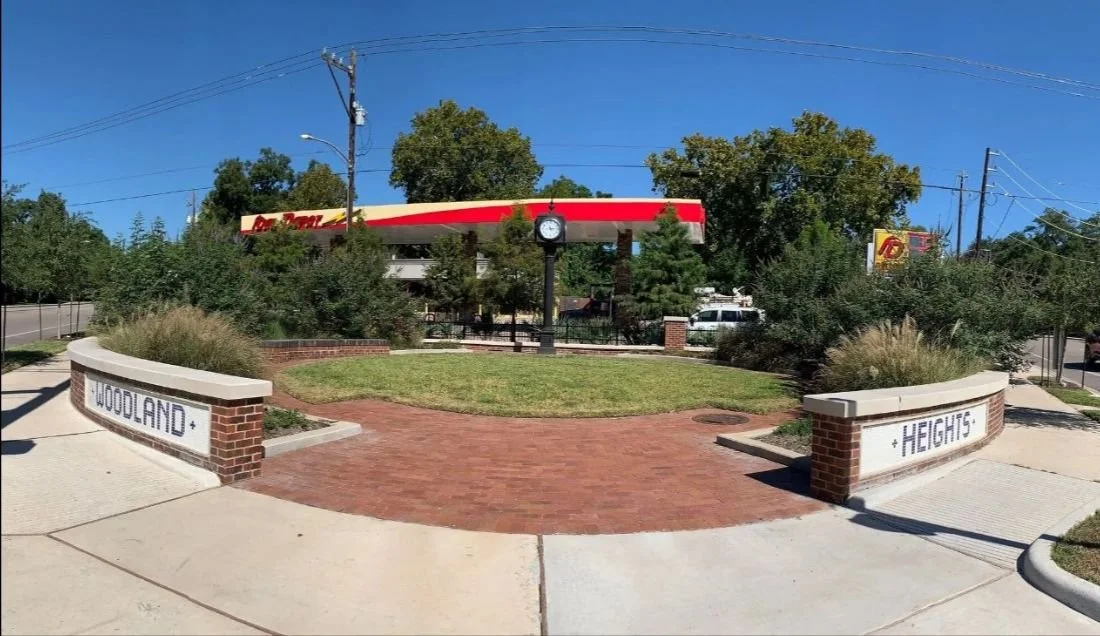
An update ... while we were so very happy to see the entrance sign off of White Oark Drive and Houston Avenue repaired. We tried really hard to not count the tiles on the Heights portion of the sign, it had taken so long to repair we didn't want to complain to loudly.
Then on a trip back home I happened to come into the neighborhood via Houston Avenue from downtown and what did I spot ...but repair crews taking the lettering off the sign to make repairs! The architect had noticed what we had that the words Heights were not centered. So a crew was sent out to remove the off-center tiles and rework them to make sure they were centered.
It's sometimes the little things that make a difference ... and we are so grateful someone noticed and came back to make the sign right!
TIRZ-5
An Update From Memorial Heights Redevelopment Authority /
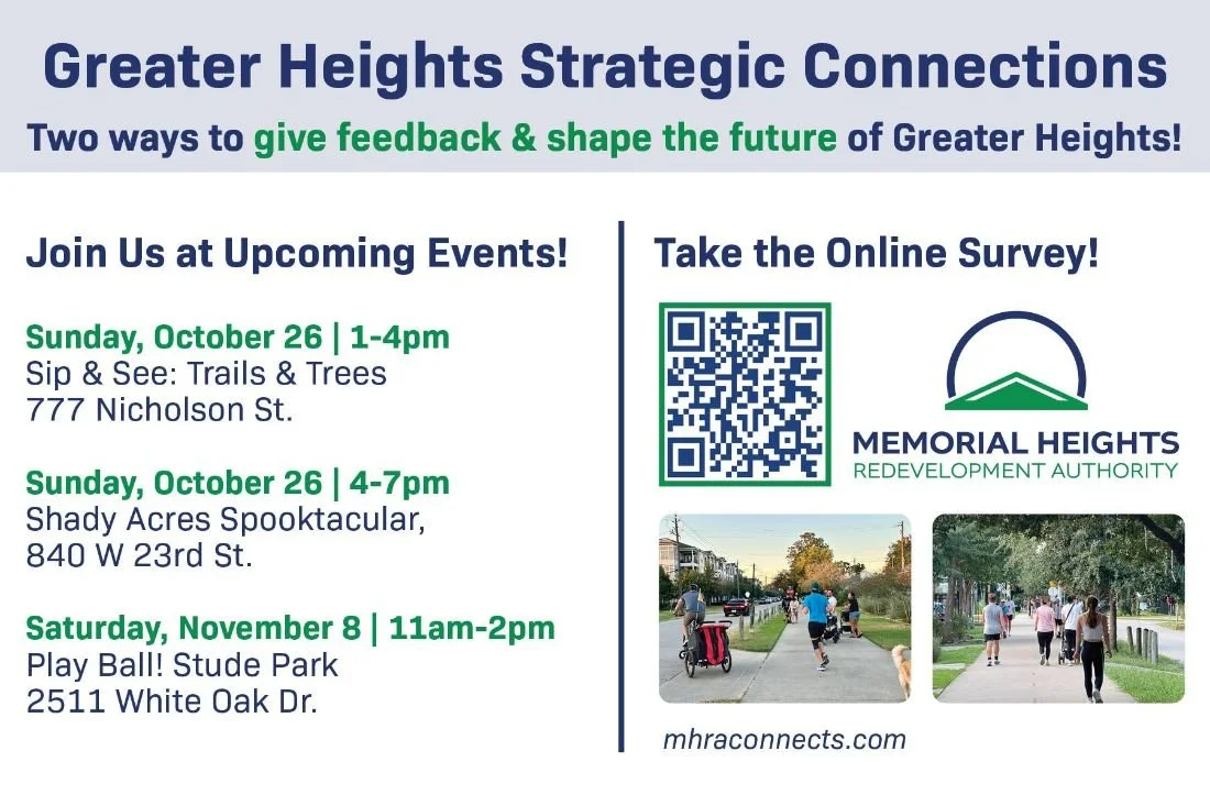
The Greater Heights Strategic Connections Plan is in its second round of public engagement, and community input is needed to identify specific streets, trails, and intersections where improvements can make the most impact.
In Round 2, we’re asking residents to help pinpoint priority locations for mobility improvements.
From now until November 16, visit mhraconnects.com/map-my-needs to mark locations where you’d like to see changes that improve safety, connectivity, and access.
Community feedback is essential to creating a plan that reflects local needs. Please share this opportunity with your neighbors.


Super Neighborhood 15 Considers Greater Heights Strategic Connections /

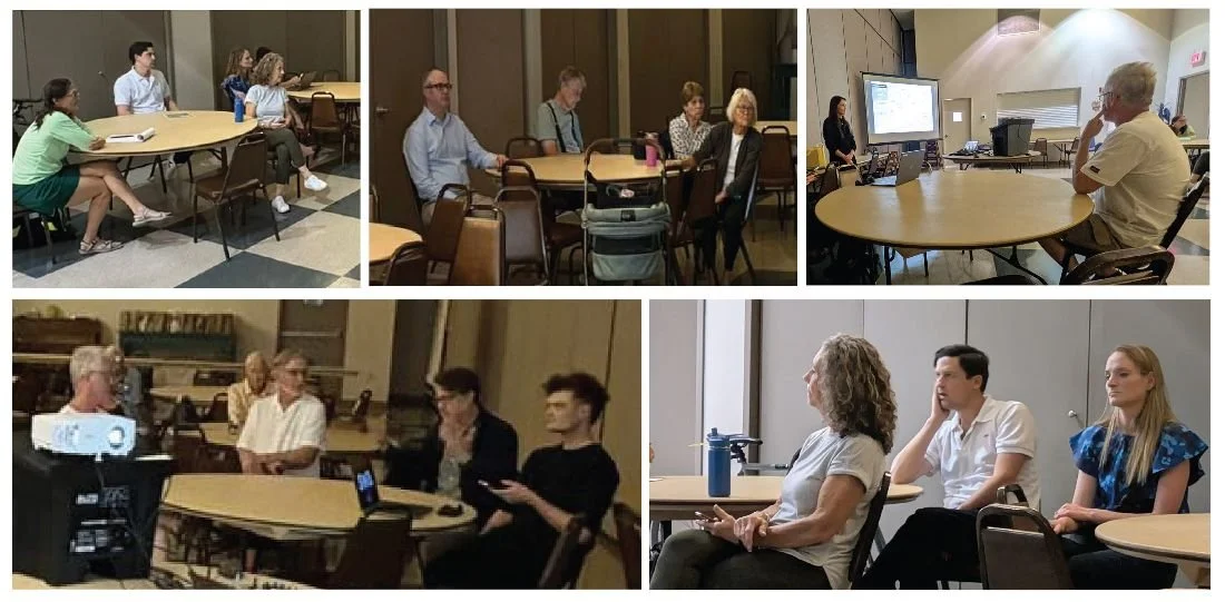
Most people are really busy in their daily lives. When they come to see changes around the city they are typically surprised – and not always for the better. That doesn’t have to be the case. At a recent Super Neighborhood 15 meeting civic associations board members were briefed on the plans to develop “Greater Heights Strategic Connections.” We are passing the information on to the Woodland Heights neighborhood so you can provide your input and have the opportunity to voice your opinion during this planning process.
This process is currently in its earliest stage, which involves studying what might be possible or desirable. They are literally asking how we might like to get around in the future. So, now is the time for neighbors to speak up.
Who is Super Neighborhood 15 - You Might Ask
Super Neighborhood 15, aka The Greater Heights, includes; Clark Pines Civic Assoc., East Sunset Heights, Houston Heights Association, Montie Beach Civic Club, Norhill Neighborhood Association, Sunset Heights Civic Club and our own Woodland Heights Civic Association. SN15 meets every second month at the old Fire Station on 12th Street. This month the focus of the meeting was a presentation sponsored by The Memorial Heights Redevelopment Authority (TIRZ5) on the plans to develop “Greater Heights Strategic Connections.”

“Greater Heights Strategic Connections” that’s certainly a mouthful, but nebulous. What does it mean? Simply put, TIRZ5 has commissioned a consulting team comprised of TEI Planning + Design, supported by Toole Design Group, to craft a comprehensive plan for how people will move about the neighborhood in the future. That’s to include;
Identify key improvements that enhance safe access to schools, parks, community destinations, and local businesses.
Build on local assets such as White Oak Bayou, MKT Trail, Nicholson Trail, Shepherd Durham Bikeway, and more.
The presentation was made by Clint McManus of TEI Planning + Design. The slide deck he used is available here.
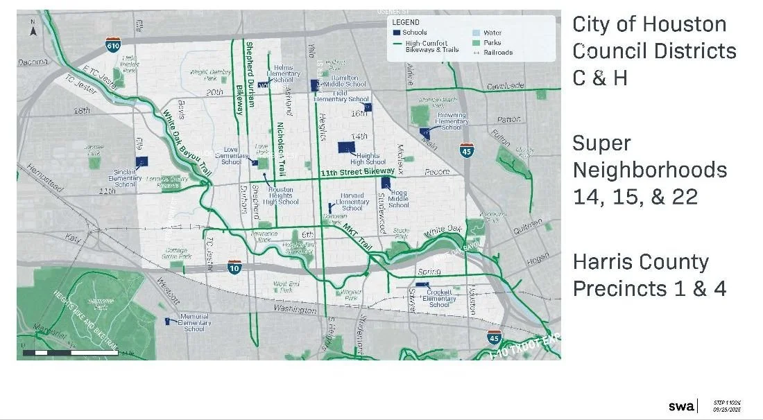
The scope of the project is quite large. It will include Districts C and H, Super Neighborhoods 14, 15, & 22 in Harris County Precincts 1 & 4. Setting aside roads, it’s an effort create a long-term strategy for mobility that includes all forms of transport, including; bikes, pedestrians, strollers, rollerblades, or whatever else might arise. It’s an effort to make a substantial part of the city better connected and accessible perhaps without resorting to the automobile. Once the plan is in place, it serves as the basis for seeking funding to enact a phased implementation.

This is an example of The Memorial Heights Redevelopment Authority (TIRZ5) working in partnership with several other organizations to plan for better mobility options as the city continues to grow. To do this well they need all our input now. It’s our job as a civic association to make sure you know that you have an opportunity (some might think obligation!) to add your voice to the process. If we all engage, we can ensure that the eventual outcome delivers safe and efficient mobility for everyone.

You can have you say by completing their “Community Vision Survey.” There’s a separate process they call “Map My Vision” that lets you enter the routes you commonly travel through the area, so they can better understand the flow of traffic.
This is an example of The Memorial Heights Redevelopment Authority (TIRZ5) working in partnership with several other organizations to plan for better mobility options as the city continues to grow. To do this well they need all our input now. It’s our job as a civic association to make sure you know that you have an opportunity (some might think obligation!) to add your voice to the process. If we all engage, we can ensure that the eventual outcome delivers safe and efficient mobility for everyone.
On The Future of Stude Park /

I believe that Stude Park is a diamond in the rough. It’s a great big green space along the south edge of the neighborhood. From the community center, playground, and pool to bike trail and ball fields, it has a lot to offer. On July 4th, the park will doubtless be full of festive families picnicking and enjoying a good view of the fireworks.
While all that is true, Stude Park could be a lot more. Recognizing this fact, the Memorial Heights Redevelopment Authority (TIRZ5) has started to work on plans for Stude Park. The process began with TIRZ5 engaging the SWA Group to study the park, its users, and their usage patterns, paving the way for crafting a design for its future.
Members of the WHCA board have participated in some initial meetings. The designers at SWA are starting by trying to understand who uses the park and learn how it might be improved to encourage greater use in the future. It has tremendous potential. While many things are being considered, one of the first changes will likely be improvements to the playground near the community center.
Unlike some other parks, there is no formal “Friends of…” group for Stude Park. Normally, a “friends” group would partner with the TIRZ5 and the designers to help gather public input. WHCA intends to fill that gap. We are seeking to ensure that the neighborhood is well and truly engaged in this effort to revitalize the park.
These are early days in what will surely be a lengthy process, but it seems apparent that the future of Stude Park will be bright. We expect to eventually seek your help to make that happen.
Infrastructure Corner /
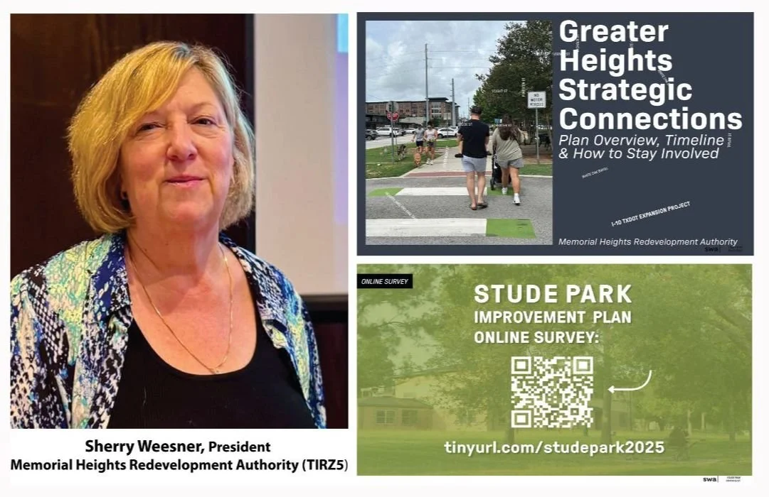
We have some updates on local area projects. Sherry Weesner, president of TIRZ 5 and the Memorial Heights Redevelopment Authority, gave an update at the last meeting of the Greater Heights Super Neighborhood Council on August 18th. The Woodland Heights is part of GHSNC council, with one voting delegate chosen by the WHCA Board (currently Brad Snead).
Here is an overview.
First, the image above is an overview of the TIRZ5 project map, which roughly follows White Oak Bayou, but also reaches along Shepherd/Durham, down Heights Blvd to Buffalo Bayou, and to Memorial Park.
Second, Ms. Weesner gave an overview of completed and ongoing projects that TIRZ 5 was involved in, including the new intersection at Houston Ave and White Oak, and the new trail head at the MKT Trail and Studewood.

Third, she gave an overview of several planned projects along the MKT Trail—along the portion from Heights Blvd to Houston Ave—which are at about 90% design completion, and are planned to start next year. (1) Heights Blvd (between Donovan Park and Heights Mercantile)—installing raised crosswalks and making other safety improvements to slow traffic. (2) White Oak Drive (next to Juiceland/Black Swan)—installing “bulb outs” at the intersection, and perhaps a pedestrian island. (3) Sawyer (next to Target)—redesigning the entire intersection, in conjunction with the developer at the corner, to give the trail priority and to make walking/biking safer. (4) Spring Street—installing raised crosswalks and making other safety improvements.
Fourth, on Heights Blvd South of I-10, they are planning several improvements. They will convert the existing bike lanes into separated bike lanes, and are planning to reconstruct the intersections at Washington Ave and Center St, and connect those lanes to Buffalo Bayou Park. In other words, you should be able to bike safely go from the Heights or White Oak Bayou Trail to the new HEB, and on to Buffalo Bayou Park, on separated bike lanes with priority at the intersections. I believe this project is also at the 90% design stage.

Fifth, they are at 60% design stage on a new connection from the White Oak Bayou/MKT Trails to Memorial Park via a CenterPoint utility corridor. The picture on the right is a little hard to see. But the trail currently ends in the Cottage Grove neighborhood, and you have to zig zag through neighborhoods and across I-10 to get to Memorial Park. This could be a significant connector for the Heights area.
Sixth, she discussed the Shepherd/Durham project, which is expected to start construction in 2022 and take multiple years. There are multiple parts, from different funding sources, but it will eventually stretch between I-10 and 610, as well as South of I-10 between Washington Ave and Memorial Dr. They are also working with Houston Metro, which has a planned Bus Rapid Transit stop planned between Shepherd/Durham South of I-10. Generally, the project will remove a car lane both directions (going from 4 to 3), add a raised bike lane (even with the sidewalk, not the road), lined with trees wherever possible. She said they plan to have two rows of trees along the bike lane where space permits, and one row of trees where space does not permit. The bike lane on Shepherd will be on the East side, and will include “floating” Metro bus stops, similar to what is being installed on Cavalcade. The bike lane on Durham will be on the East side as well because of limited right of way. She also explained that they engaged two engineering firms, both of which concluded that the congestion on Shepherd/Durham is not from amount of car lanes, but from the design of the turns. This project should alleviate that congestion while making it safer for other road users.
Seventh, she mentioned several other projects they are assisting with, in conjunction with the Montrose TIRZ and others, putting bike lanes on West Dallas and Dunleavy, adding connections in the area South of Buffalo Bayou between Shepherd and Waugh
Finally, she discussed a question we raised about TIRZ5’s interest in working with neighborhoods to do small projects. She said TIRZ5 usually gets involved in big projects, but likes to take 1 to 2 small projects a year that can be done quickly. They would like to work with neighborhoods as well, if we can find funding for half or so (and she mentioned other potential sources of funds and grants). The WHCA Board will discuss this, and would like input from the neighborhood, on what types of projects we’d like to see to help us connect to these other projects. For example, we could use this to create a bike/pedestrian crossing at White Oak Dr from our neighborhood so we can access the bayou trails more safely.
So there are a lot of things in the works for the coming years. Please email any comments, ideas, and suggestions to infrastructure@woodland-heights.org.
Brad Snead
Director of Infrastructure
Update on the Houston Ave - White Oak Drive Project /
The following was submitted by Pat Rutledge following a TIRZ-5 meeting the morning of February 28th.
Here is a brief overview of the current status of the Houston Ave. / White Oak Drive intersection redevelopment project.
Originally the project was scheduled for completion in late March 2019. Currently the completion is expected to delayed slightly and be completed by mid to late April 2019. Rain is responsible for some of the time delay but the greater culprit is the delay in removing the privately owned “telephone” poles: CenterPoint, AT&T, and AT&T Legacy, etc. However that work is now expected to begin and be completed the week of March 4th. After that is completed the remaining work will concentrate on the Woodland Heights Gateway at the north west corner of the intersection. Additionally the entire intersection will receive an asphalt overlay at the end.
This project is the first to meet the newly revised city guidelines for traffic safety and pedestrian walkability, i.e. the new mobility plan.
As an added enhancement City Council District H has funded an extension of the street level bike lane from the intersection south to intersect with the MKT Trail that crosses Houston Ave near Spring St.
The WHCA Clock Tower has been completely refurbished and is awaiting transport and installation into the Gateway as that part of the project is completed.
The most recent printed update on the project and the supervising company (Jones and Carter) is available for download here.
This tremendous improvement to the neighborhood will significantly beautify the south east entrance to the community while making pedestrian and bicycle use much safer.
Pat Rutledge
Friends of Woodland Park